Tuesday, December 6, 2011

2012 Michigan Lighthouse Calendar

Beautiful all seasons 12 Month Michigan Lighthouse Calendar by photographer John McCormick.  (Michigan Nut)  

Lighthouses Include:

  • Big Sable Point Lighthouse
  • Grand Haven Lighthouse
  • Aux Barques Lighthouse
  • Point Betsie Lighthouse       
  • Eagle Harbor Lighthouse
  • St. Joseph Lighthouse
  • 40 Mile Point Lighthouse                             
Limited Quantities selling $3.00 above cost!


Wednesday, October 12, 2011

"Leaves on the Stream" Bond Falls - Paulding , Michigan

Via Flickr:
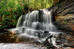
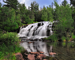
A rainy Autumn morning at Bond Falls. I've been visiting Bond Falls for many years and finally got that great capture I have wanted to hang on the wall.  We spent a week in Upper Michigan photographing waterfalls and other Autumn scenes with only one of the day's having any sunshine at all.

While this isn't the best vacationing weather it, it is he best conditions for photographing waterfalls and Autumn color.  The soft light and the wet leaves make for beautiful photographs .

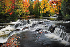
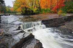
This photo is Upper Bond Falls and Lower Bond Falls can be seen here.

A map to Bond Falls location is here from Michigan interactive.                                      

Please visit my website for prints, canvas, and other stuff, or to view my
galleries. 

also available for Royalty-free Stock Image Licensing. or personal use high resolution downloads


Michigan Nut Photography


Camera settings for this shot

Camera - Nikon D700
Lens - Nikon 16-35mm
Focal length - 29mm
Exposure - 1 sec
Aperture - f/14
ISO Speed - 200
Quality - raw processed in capture NX2
Tripod - manfrotto-proxb

© Copyright 2011 John McCormick , All Rights Reserved.

Tuesday, October 4, 2011

(Upper Canyon Falls) - Sturgeon River - Near L'Anse, Michigan

Via Flickr:
The colors were gorgeous along the Sturgeon river. Another day of shooting in the rain thanks to my wife holding the umbrella. If your not afraid of getting wet Autumn photography is stunningly beautiful when it is wet cloudy and raining.   The colors are way more saturated and the lighting is ideal for long exposures of waterfalls.

Upper Michigan's rivers and waterfalls give a beautiful show of color often turning faster than higher elevations.   I used a (CPL) circular polarizer in this shot of Michigan's Canyon Falls to reduce glare in the water , rocks and leaves.  

Here is a map to Michigan's Canyon Falls  , from Michigan interactive.

Please visit my website to view my complete Michigan galleries or to purchase prints

also available for Royalty-free Stock Image Licensing. or personal use high resolution downloads


Camera settings for the above capture

Camera - Nikon D700
Lens - Nikon 16-35mm
Focal length - 22mm
Exposure - 1/8sec
Aperture - f/11
ISO Speed - 200
Quality - raw processed in capture NX2
Tripod - manfrotto-proxb

© Copyright 2011 John McCormick , All Rights Reserved.

Wednesday, August 17, 2011

Big Sable Point Lighthouse - Ludington , Michigan

Via Flickr:
This Beautiful Lighthouse sits close to the shore of Lake Michigan's Ludington State Park. It's a two mile hike to see Big Sable, so bring a flashlight if you plan to see a sunset.  This Michigan Lighthouse is in a beautiful location tucked in along side Lake Michigan's rolling dunes.

I good tip if your planing to visit Big Sable for a photography shoot is to load your bicycle up and take it with you. Vehicles are not allowed and it is about a two mile hike.  The hike is great but if you stay late and shoot the sunset it's a pretty dark walk back

As always if you have any questions about visiting this Lighthouse or any other photography related
questions, just drop me a line jmphotography@casair.net

Tuesday, August 16, 2011

"Night Lights" Mackinac Bridge Mackinaw City Michigan.

Via Flickr:
The Mackinac Bridge (pronounced /ˈmækɨnɔː/, MAK-in-aw), is a suspension bridge spanning the Straits of Mackinac to connect the  Upper and Lower peninsulas of  Michigan. Planned since the 1880s, the bridge was completed in 1957 only after many decades of struggles to begin construction. Designed by engineer David B. Steinman, the bridge known as "Big Mac" and "Mighty Mac") connects the city of St. Ignace on the north end with the village of Mackinaw City on the south. It is the longest suspension bridge between anchorages in the Western hemisphere. The Mackinac Bridge carries Interstate 75 across the straits.

The photo in this blog and all of my work can be purchase at my website Michigan Nut Photography as prints,canvas,mugs/glasses..etc..

also available for Royalty-free Stock Image Licensing. or personal use high resolution downloads


Thursday, August 11, 2011

"Sunset silhouette" Grand Haven Lighthouse - Grand Haven , Michigan

Via Flickr:
Dozens of people line the pier at Grand Haven to watch this beautiful sunset.
Grand Haven is located on the eastern shore of Lake Michigan at the mouth of the Grand River, for which it is named.

If you want to capture a Michigan Lighthouse with huge waves crashing on it  for a dramatic photograph , this is a great one to do it at.   I took this photo at grand Haven last fall during gale force winds in excess of 60mph.

You can see my complete Michigan Lighthouse slide show  here.

Monday, August 8, 2011

Bond Falls - Paulding Michigan (Middle Branch Ontonagon River)


Bond Falls is on the middle branch of the Ontonagon river just a few miles east of Paulding Michigan , in southern Ontonagon County. The falls drops about 50ft and has a wide crest of over 100ft.  The cascade is split into two sections only the one section can be seen in this photo.  Here is a nice map from Michigan interactive showing how to get to the falls from Paulding.

If your a waterfall enthusiast this is one Michigan Waterfall that shouldn't be missed .

Wednesday, August 3, 2011

"Michigan's Paradise" Lake Superior , Pictured Rocks National Lakeshore

Via Flickr:
If you have never taken this hike along Michigan's Pictured Rocks National Lakeshore , and you are able and willing , you wont regret it if you do. Michigan is amazing and this hike is second to none in my opinion.

We have been hiking this area for over 30 years. This is also a top spot for Great Lakes Kayaking.  Some of the most beautiful sea caves arches and coves can be seen by kayaking Pictured Rocks.

If you enjoy waterfalls , at the west entrance to pictured rocks is the hilly picturesque little town of Munising .  The Munising area has several waterfalls that are easily accessed.   Munising FallsWagner Falls , Scott Falls  to name a few.

See My - Pictured Rocks Slideshow -

The photo in this blog and all of my work can be purchase at my website Michigan Nut Photography as prints,canvas,mugs/glasses..etc..

also available for Royalty-free Stock Image Licensing. or personal use high resolution downloads

Submit Photos to Shutterstock and make $$$!


Any photography related questions or more information on Pictured Rocks National Lakeshore , just
Email me

Camera settings for this shot:
camera - Nikon D700
focal length 18mm
Lens - Nikon 16-35mm
Exposure - 1/60sec
Aperture - f/11mm
ISO Speed - 200
Quality - raw processed in capture NX2
Filter - cpl
hand held

© Copyright 2011 John McCormick , All Rights Reserved.

Wednesday, July 20, 2011

Tips for getting accepted into microstock agencies

Mackinac Island trail - Mackinac Island , Michigan
Trail on Mackinac Island

If you want to get accepted as a contributor into microstock sites like shutterstock you have to submit 10 photos for review and 7 of them have to pass.

Some tips for getting accepted are:

Thursday, July 14, 2011

"The Storm" Grand Haven Lighthouse , Grand Haven Michigan

Storm force winds pound the Grand Haven Breakwater Lighthouse
in this October , 2010 scene.   My favorite time to photograph lighthouses is in the fall when the strong low pressure systems blast through pushing strong storms and north winds.  Grand Haven is one of my favorite places during these events

For me the best way to capture these big waves crashing is to use a mono-pod or take your tripod but don't open the legs, extend them but just leave them together. You can move around easier that way plus 45 to 65 mph winds don't agree with tri-pod legs much. Hold the camera steady, compose a good shot, watch through the viewfinder and wait for a nice big wave crashing into the lighthouse and then let the shutter fly a few times.

Tuesday, July 12, 2011

"Graveyard Coast II " - (Mary Jarecki shipwreck) , Pictured Rocks National Lakeshore

The Mary Jarecki was a wooden bulk freight steam Ship 645 tons, 200 feet in length. It hit Au Sable Reef and went down on July 4, 1883. She lost her way in heavy fog that frequent the area. These shipwrecks are a reminder of the incredible power of Lake Superior.

The Jarecki shipwreck is located on the shore of Lake Superior just north of the mouth of the Hurricane River.  Here is a nice Map of Pictured Rocks National Lakeshore  by Michigan interactive.

Monday, July 11, 2011

"Miners Castle Sunset" - Pictured Rocks National Lakeshore - Munising , Michigan


I'm always looking to find a different point of view when photographing places that have been photographed over and over again although my guess is quite a few people have captured Miners Castle from this perspective. One leg of my tripod was hanging off the cliff which rises 200 feet above Lake Superior. The spot I am standing on is undercut from erosion so it's kind of scary. Definitely have to be very cautious...

Sunday, July 10, 2011

"Rock River Falls" Rock River Wilderness Area - Near Chatham , Michigan


 It's quite an adventure getting to this remote waterfall located in the rock river wilderness, Hiawatha National Forest. We drove five miles in on an old two track , parked and walked additional 1.5 miles or so on an unmarked trail. I have been to dozens of waterfalls in Michigan but this was our first time to Rock River falls . This falls is not huge but is now on my top five favorite Michigan waterfall list. After I photographed the falls I climbed up and enjoyed a refreshing shower. It didn't look like anyone had been there in awhile.

Friday, July 8, 2011

"Spray Falls" Michigan's Pictured Rocks National Lakeshore

Spray Falls in my opinion is the most impressive of the waterfalls in Pictured Rocks National Lakeshore. The 70' waterfall shoots over the cliffs at Pictured Rocks and lands directly in Lake Superior. It took my wife and I about three hours to hike to this lookout of the falls , we stopped a couple of times for a drink and to take other photos. T o get a great late evening shot of  Spray Falls , you would have to pack in and camp overnight because of the long trek back to the trail head. Here is a Map of Pictured Rocks National Lakeshore from Michigan interactive.

About Me

My photo
Hi, My name is John McCormick I’m an avid Michigan / Great Lakes Landscape Photographer. I am a life long Michigan resident and have been into landscape photography for over 30 years. On my website Michigan Nut Photography I offer high quality Fine Art Prints for the home and office. Also available are canvas wraps, standouts, framed prints, mugs, glasses, magnets, and a variety of other gifts and merchandise all of which can be printed on with a photo of your choice in my galleries.